The Southerly Bluster is a colloquial expression for strong southerly winds that sweep up the New South Wales coast at the end of a hot summer’s day. Records show that about 30 southerly buster fronts move up the coast annually. However, only in 5 or 6 cases each year do the climatic conditions align sufficiently to produce real Blusters.
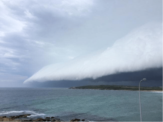
For the really big blusters, you need a strong cold front travelling north east up the coast to arrive over Sydney in the hottest part of the day, generally late afternoon. If this occurs you can get an impressive rolling cloud front accompanied by 40-50 knot winds and a temperature drop of up to 15°C in 30 mins. This is the classic Southerly Bluster.
So what causes them?
A southerly buster usually occurs in spring and summer and there are a number of geographical and climatic conditions required to generate them:
- In the southern hemisphere, you need a mountain range running near an eastern coastline, our Great Dividing Range does just this.
- An existing cold front that is moving perpendicular to the mountain range.
- Hot air ahead of the front.

Cold fronts in Australia typically travel north east, as does our Great Dividing Range. As the front progresses along the mountains, the cold wedge of air pushes up the warm air ahead of it as in any normal cold front. To balance the forces at work in the front (the pressure difference between the warm and cold air and the Coriolis force produced by the earth’s rotation) a cold wind develops behind the front that runs at right angles to the direction of motion of the front. This wind is called a Geostrophic wind, and In the Southern Hemisphere the wind will blow to the left (looking in the direction of travel of the front). Along the NSW coast this westerly Geostrophic wind is blocked by the face of the Great Diving Range, and as it can’t escape, veers north. The result being a cold blast of cold air rushing up the NSW coast.
This air cold blast over the coast moves ahead of the air running along the mountains, which slows due to friction and this this distorts the cold front into an ‘S’ shape instead of a straight line, Synoptic charts will generally demonstrate this.
The bigger the temperature differential of the cold front, the greater the buster. On the far south coast of NSW the enhancement of the front due to the temperature difference effect is not great. This effect reaches a maximum intensity between Nowra and Newcastle (Sydney being right between the two towns) and rarely has much effect north of Coffs Harbour.
Southerly Blusters are generally very well forecast, although, the exact time of arrival can be hard for the Bureau of Meteorology to predict, so it’s best to be cautious. While a strong weather system, they are usually short lived. In fact within a couple of hours of the front passing winds will have eased substantially. So if you are caught out, reduce sail in advance and hang on!
Photo courtesy of Daily Telegraph.

Leave a comment