Route planning a trip across the Atlantic Ocean east to west involves a few decisions. The big one is whether to cross during or outside the Hurricane Season, which runs from May to October each year. For me it’s a no brainer, I wouldn’t cross in the hurricane season. But plenty do – Simon, one of the fellas on Fourth Dimension IV crossed the Atlantic for the first time in a Moody 33. He went in August, at nearly the height of the hurricane season. But then he was 19 and that’s how you roll when you are a teenager; risk is secondary to the promise of rum and bikinis in the Caribbean!
Once you have established to go in the winter and outside of the hurricane season you need to then consider what month to go. Ideally you want the north easterly trade winds to have fully developed. These start fitfully in November and really achieve full strength in December and January. The challenge for most yachts heading to the Caribbean is that upon arrival they want to enjoy a few months sailing before the hurricane season starts. This pushes them to head off in November before the trades have developed which can lead to light and variable conditions.
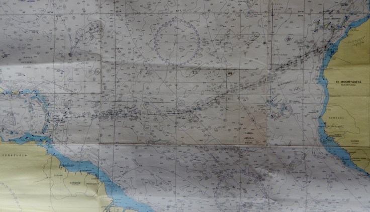
Next decision is the actual course you take. The Great Circle is the shortest distance between two points on the globe. So to keep your distance down you need to keep close as possible to this line. The great circle is not always easy to achieve and its successful execution relies on the right conditions. Beyond this route there are the northern or the southern routes. There are advantages and disadvantages to each.
Go South, then West “Southern Route”
The southern route is generally accepted as the traditional route and should provide a more consistent and comfortable down wind ride. Although as we found this year, we didn’t reach the trade winds until we were at a latitude of 15 degrees, a good 600 NM south of the canaries.
Go West, then South “Northern Route”
With well-established high pressure over the Azores, a direct (that is, northerly) route is usually fastest, staying far enough away from the high to keep the wind, but minimising distance following the great circle route. However, the less established the high is, the greater the chance of a mid-Atlantic trough or low developing, giving adverse winds.
The challenges come as there is an increased chance of meeting head winds and the winter low pressure systems from the north Atlantic can drop down in latitude which can cause quite tough conditions, with large waves. Occasionally, named tropical storms develop mid-Atlantic. In 2015 a small low early in December was given a 50 per cent chance of developing into a tropical storm by the National Hurricane Center (USA), this would have generated very tough conditions if it had materialised.
In summary, the advantages of the northern route, need to be balanced against the risk that a Low to the North could deepen and track across your route.

Great articles Richard!
LikeLike